
Following our one-night stay in Portland, my family and I packed our bags and headed off for our next destination during our road trip in the Pacific Northwest this past summer. This time, we would be trading the concrete jungle with natural scenery, as we made our way to the Columbia River Gorge for a series of lush, deep valleys and waterfalls to take pleasure in.
Straddling the border of Oregon and Washington, the Columbia River Gorge is a large canyon which brings both the Columbia and Deschutes Rivers together. The canyon extends for around 80 miles (130 kilometers) and is part of the Cascade Range, which is a cluster of well-known mountains such as Mount Hood, Mount Rainier, and Mount St. Helens, all of which we would be visiting in due time. It is also home to the famous, two-tiered Multnomah Falls that continues to impress visitors with its sheer drop from what seems like the heavens. In essence, the Columbia River Gorge offers nationally-protected scenic areas for exploring, whether through hiking or for merely admiring from the distance.
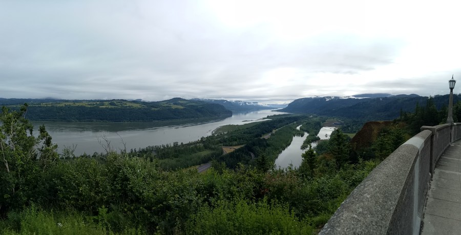
My family and I would spent the day taking a scenic drive through the Columbia River Gorge, making stops along the way to see the waterfalls and natural sites that we’d bookmarked to see in advance. We left Portland around 8:00, making the one-hour drive east to the entrance of the gorge. Our first stop was at Crown Point (also known as “Thor’s Crown”), a cliff side point which offered fantastic views of the Columbia River Gorge itself.
Seriously, the views were breathtaking: words cannot describe just how unreal they were, like something out of a computer home screen. The early-morning fog hung coolly in the air, offering us some relief as we snapped photo after photo of the valley in front of us. We also climbed the Vista House observatory to get clearer views from up above.
We were off to a good start: we continued on to our first waterfall of the day at LaTourell Falls. What makes this particular waterfall distinctive is that instead of tumbling down like many other ones, it drops straight down– all 250 feet (76 meters) of it. My family and I made a stop to walk down to the source, where apparently you can climb all the way down to the rocks and literally stand right in front of LaTourell itself! Feeling brave, I made the muddy, grassy descent to the waterfall, and I felt the powerful misty spray of the natural waters on my glasses as I triumphantly posed for a photo at the bottom of it. My pants got a bit dirtied in the end, but it was certainly a thrilling experience!

The next stop was at Shepperd’s Dell, a small canyon with an equally-small waterfall. Its drop wasn’t as high as LaTourell’s, but it still was pleasant with its white-water characteristics. The Shepperd’s Dell Bridge loomed above us from the bottom of the canyon, giving off what I would call “true, Pacific Northwest vibes” (if that’s such a thing).


Waterfall #3 took us to Bridal Veil Falls, its distinctive name given due to the particular angle off which the water tumbles, thereby looking like something out of a wedding ceremony. Interestingly, there’s a nearby town called Bridal Veil (known to be a ghost town today) where couples ship wedding invitations to have that treasured postmark, to show that, indeed, their wedding is just that special. My family and I had to hike about 2/3’s of a mile to the source, and by then, the weather was starting to warm up.

Around 11:30, we reached the iconic Multnomah Falls; I was very much looking forward to seeing it, since it was the highlight of the Columbia River Gorge. First things first, however, we had to find a parking spot! We spent easily half an hour trying to find space along the road, since the parking lot in front of the waterfall was completely occupied. Eventually, we squeezed our small rented red car into a spot on the roadside and headed over.
By the time we’d arrived, the day was in full swing and tourists were swarming everywhere to get pictures of Multnomah Falls. The two-tiered waterfall was absolutely beautiful in person, with its distinctive bridge separating the levels of the tumbling water. Only *slight* disappointment was that the sun was set behind Multnomah itself, which made my photos dark whenever I tried capturing it. Nevertheless, it wasn’t so bad (helps with a bit of editing!) and we ventured up to the bridge for a closer look, even seeing a double rainbow in the process!

Beside Multnomah Falls was a tourist lodge where we got a quick lunch (a bit pricey, but it’s expected of a touristy place) and later made a half-mile walk to Wahkeena Falls nearby. This particular waterfall was nothing like I’d seen from what we’d visited that day: rather than having a single, plunging effect, it resembled sort of a thin, web-like appearance as it trickled down the various channels. What made it even more special was that it was sort of off-the-beaten path, as we didn’t see a whole lot of visitors come over– perhaps they were too focused on seeing Multnomah Falls!

Soon after, we returned to our car and made a stop or two at several other waterfalls (which unfortunately, I can’t remember their names) before leaving the Columbia River Gorge in the early afternoon. We winded through the cliffs and valleys of the surrounding area on our way to Hood River before making a stop at Rowena Crest, known for more gorgeous views of the deep-blue canyons and well-known horseshoe curves on the highway.

Towards 15:30, we decided to head straight to Hood River, a small town near the eponymous river itself, where we would spend the night. Driving down from Rowena Crest, we saw and stopped by a cherry stand on the roadside to taste and buy the fruit– after all, it was $2 per pound, which wasn’t bad at all! We bought two pounds worth of ruby-red cherries, which are locally-grown and native to the Pacific Northwest. They were probably some of the tastiest cherries I’ve had, with just the right amount of sweet and tart in each one– took us perhaps three days to eat them all, but they were worth the purchase!
Arriving in Hood River in the late afternoon, we checked into our hotel and rested a bit in our room before heading into town for dinner. We ate at a rather-classy restaurant situated on a hill overlooking the gorgeous river: it also happened to be Father’s Day, so we treated my dad to a lovely dinner of fresh halibut and Pinot Noir. Finishing up dinner, we returned to our hotel to rest for the remainder of the night. What surprised me was that the skies didn’t turn dark until past 21:00, a true indicator that summer had, indeed, arrived.
Overall, it had been another long day of driving, but it turned out to be less stressful than the day before in Portland. I attribute it to the fact that we explored the nature side of things, which I suppose had a calming effect on us. More nature was to come the day after, as we continued our trek through the state of Oregon (soon-to-be Washington).
Coming up: Mount Hood, Oregon!
— Rebecca

That looks stunning thank you for sharing
LikeLiked by 1 person
Thanks for reading!
LikeLike
Beautiful!
LikeLiked by 1 person
Probably one of the highlights of my time in the Pacific Northwest! 😀
LikeLiked by 1 person
This looks like such a picturesque region with all those waterfalls! That’s so cool that you can actually get right up beside some of them too – reminds me of some of the waterfalls I went to in Hamilton, up near Toronto 🙂
LikeLiked by 1 person
Certainly a beautiful region just a state away from mine! I imagine getting up close to a waterfall is like taking a *really* heavy shower…at least you’ll be clean afterwards! 😀
LikeLiked by 1 person
Crazy to think it’s so close to California, yet the landscape is so different! It’s like nature’s answer to a power shower 🙂
LikeLiked by 1 person
Amazing photos!! Waterfalls just look so magical, creating such beautiful scenery!
LikeLiked by 1 person
I agree! Thanks for reading.
LikeLiked by 1 person